

Our anemometry field work, having given us difficulties all summer, is finally starting to get easier.
Easy is relative, of course. It's never easy to wrestle these huge steel towers by hand up and down the state of Maine. Several times this summer I've wished for a team of mules or a tractor with some kind of super duper four wheel drive, anti-tip-over system.
With backhoe, loader, trailer and forklift permanently attached so you could use whichever you wanted any time you needed.
I don't think they make those, but if they do, that's what we'd need. That and the mules.
But what we have instead is sweat, sweat and more sweat, elbow grease, and of course, old fashioned brute force and ignorance.
Did I mention the sweat?
Anyway, sweaty scene-setting aside, there is a purpose to all this hard labor. We're trying to measure the wind for serious scale wind turbines on community-owned, state-owned, or farm business sites. About the only place we won't measure the wind is a private residence that happens not to be a real farm, ie, more than 50% of income from farming. Those we don't do. Nor do we measure wind for small scale turbines that are cheaper than anemometry equipment. That's a no-brainer.
And we don't measure for large scale commercial farms, although there's nothing to stop a Maine town government putting in a substantial, money-making, green-power making, community-owned wind farm if they so wish, such as the Fox Islands Wind Project (one of our anemometry sites earlier this year).
But if you're a farm, a town, a non-profit, or a branch of the state or federal government, we will help you out.
All the data is in the public domain, and anyone who wishes and has the knowledge to use it can contact me and get a full data set for any of the sites where public money has been used to pay for equipment or labor. Of course, this is data, so it's not very interesting unless you can crunch numbers, but we give it out for free to anyone who asks for it.
We also use the same data to read the Maine wind map very carefully, correcting intuitively where we can, and we make custom poster-size or computer-file GIS-based wind maps for anyone who asks.
At this point we have good data from enough sites in the state of Maine that we can correct the wind map for a lot of places. Not all, but enough to begin to save people time and trouble. We have enough anemometry data from our sites and those run by our partners, the University of Maine's anemometer loan program, that if you have a site in mid-central Maine, we can in some cases give you a fairly accurate wind assessment without needing to measure the wind.
Other parts of Maine, not so good. The wind map, which was made for the federal government by a private contractor in 2007, has been inaccurate enough in three or four places that we know of to encourage a project on an unsuitable site, or discourage a suitable one. We need to measure in other areas, eastern and northern Maine, and then correct the map properly, scientifically: actually correct the algorithm or wind model the map is based on.
Bit by bit, we're getting out there. This is a five or ten year project.
Yesterday's job was to finalize our biggest project of the summer, the Mercer site. This is a private farm where the owners are interested in having a farm turbine, possibly with their neighbors or community involvement. It's a mid-central Maine hilltop in a region were the wind map numbers are most inaccurate. We have sites in this region where we've measured the wind and found it to be stronger than the map number by two full wind power density classes, a Class 4 site instead of a Class 2.
Oops. Need a number check, please.
So we wanted a bit more data on that issue, and the owners wanted data to decide on their turbine, and there was federal and state money available through USDA and our partners the Efficiency Maine Trust. Maine Rural Partners, a regional agricultural advocacy organization working for farm energy efficiency and commercial viability, among other desiderata, did the outreach.
But the sweat, dear readers, was all ours. Although we had a good deal of useful and sweaty help from the farmers.
This site gave us more than the usual amount of trouble and at least one of the wind workers said that she was "done with" driving out there even though it has a nice view and there happens to be a good coffee shop along the way. We put in about fifteen or maybe twenty field days on this site, not counting the six or seven days to initially recover the equipment from the previous site, which itself was a very inaccessible mountaintop, requiring each component to be carried about half a mile down a steep trail.
The problem with Mercer was the clay soil. It had clay pan at 2-3 feet, very well drained this time of year, and hard as iron. This clay defeated no less than three different power augers, each increasingly larger and more powerful. You could chisel it away in small chunks with an iron bar, each blow requiring the full force of a pretty strong guy, but that's no way to run a railroad.
Eventually we got a back hoe and dug big holes and buried nautical-style "deadmen" anchors, using recycled wheel rims slipped over our screw-in anchor rods. There's nothing quite like a rusty sixteen-inch wheel rim under four feet of clay or glacial till, rocks and all, to give you a decent anchor. (Thanks to TA's Automotive and Salvage, a very fine and public-spritied organization, for the rims.)
Earlier this week we pull tested similar anchors at the University of Maine's Peaks Island wind site to 4,000 pounds. They would have held more, but that was already 500 pounds more than the required load, so we left off at that.
Here's wind worker Steve on the ferry to Peaks, looking positively vacational. Don't worry. By the ride back, he was good and sweaty.

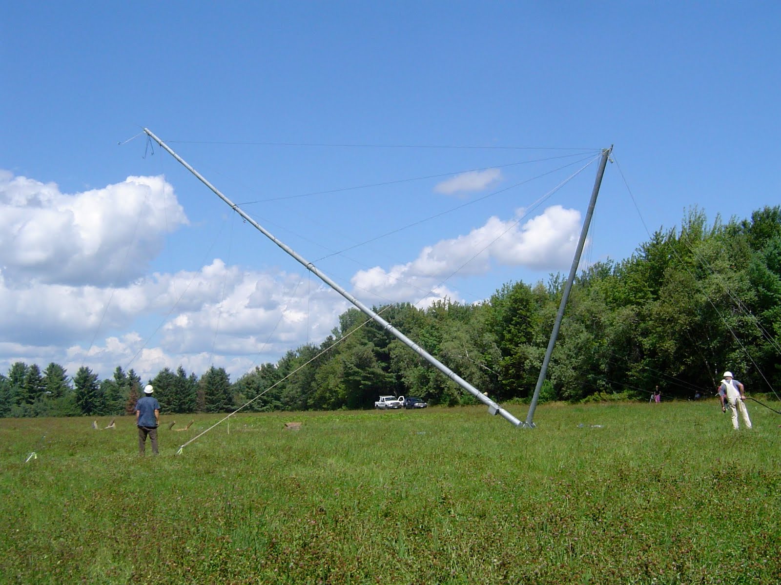
The equipment we used at Mercer was a NRG Systems 60 meter tower, which we reconfigured as a 30 meter tower for this site.
Although we started our wind program four years ago with the 60 meter equipment, the University of Maine started with 30 meter, and since we need compatible data to correct the wind map, and since 60 meters is twice as big and twice as scary, and finally, since the community partners are usually thinking of smaller turbines, we decided to use 30 meters from here on out in most of our program.
That means we get to make two 30 meters out of each 60, although we have to buy some extra base plates and guy lines to do this.
The NRG towers are called "tilt-up" towers because they hinge at the base plate, and are lifted by a winch and a "gin pole." They flex a lot and make scary noises going up and coming down. Sometimes they fall down, especially if you're inattentive to the cable tension as you raise or lower the tower. We had one fall down earlier this summer. Not for the faint-hearted.
You need to be an experienced rigger, and even then you need the NRG Systems training, to think about working with this equipment.
(The Mercer site equipment was given to our wind program by both NRG Systems and Competitive Energy Services, for which we are grateful.)
Long story short, with the deadmen and recycled and donated equipment, we were able to get an anemometer on the Mercer site for much less than the going costs. And we're collecting data that will be in the public domain. It will be accessible and free, and if you are a community organization in the mid-central area, this data will allow you to rule in, or rule out, a community turbine, for free.
When it would normally cost between $20,000 and $50,000 depending on the height of the anemometer tower. This expense, and commercial competition, means that private wind power developers generally keep their data secret.
We don't keep data secret. We collect it using public money, and so we give it out for free. We think this is a good deal, since there are very few communities that can afford this. We also feel that public wind data is more efficient and valuable than private data. This is, after all, very basic science, and although the commercial value is high, if the data is privately held, no one is looking at it in a coordinated way, and that costs everyone.
The data can also be used for proper public planning, since the turbine noise nuisance varies based on the wind. Towns and municipalities can properly plan to reduce noise, another good reason to think that public data is better than private.
We have one more day today at the Mercer site, a clean-up day. After that we have one more site to set up this summer. Then we're done with field work for a while.
Which is good, because although I enjoy the work, and although I need the exercise, I am a little tired of all that sweat. It will be nice to go out to these sites in fall and collect the data when it's a little cooler.
2 comments:
Hey Mick and Team,
You guys (and gals) are doing great field work. There is quite a growing market for skills in the renewable energy field be it tower installers for wind assessment, wildlife studies for potential wind farm sites or mangement and maintenance of wind turnbines. All of this work equates to local jobs and keeping the value in our community. Of course it also supports our overall environmental values.
Keep it up!
Thanks Phil!
Of course, none of this would have happened if it wasn't for you.
Post a Comment